
−20 m · Stone · Maya Ruins · Yucatán
Kulubá, Yucatán: Maya Ruins on the Route from Chichén Itzá to the Sea
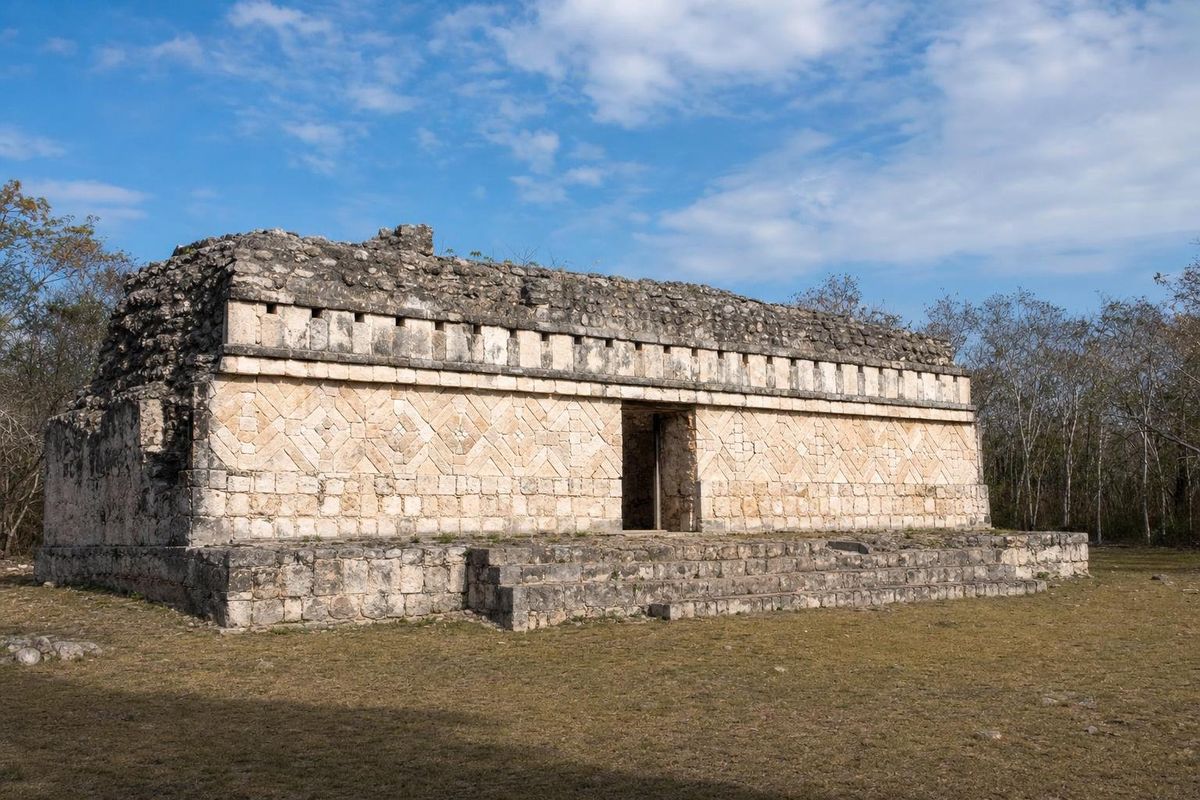
Kulubá is a Maya archaeological site in the municipality of Tizimín, in the cattle country of eastern Yucatán. Its buildings, dated mostly to the Late and Terminal Classic, roughly AD 600 to 1000, show a mix of Puuc-style stone mosaic and features associated with Chichén Itzá, which has led archaeologists to see it as a town tied to the Itzá network and to the trade routes running between the interior and the north coast.
What Kulubá was
For most of the twentieth century Kulubá was known to specialists and to the ranchers whose land it lay on, but hardly to anyone else. The site was surveyed and partly excavated over several decades, and in recent years INAH, Mexico's national institute of anthropology and history, has cleared, consolidated and restored several structures and prepared the site for visitors.
Kulubá was not a capital on the scale of Chichén Itzá or Ek Balam. It was a regional center: a cluster of plazas surrounded by palace-type buildings and platforms, with outlying residential groups spread across the surrounding land. Its interest lies in where it sits and in what its buildings say about the political map of northern Yucatán at the end of the Classic period.
Between two powers
In the ninth and tenth centuries northern Yucatán was dominated by a few large cities. Ek Balam controlled much of the north-east; Chichén Itzá was rising to become the most powerful city in the north. Kulubá lies between them and the coast, and its architecture reflects both worlds.
Some buildings use the finely cut veneer stones and mosaic facades of the Puuc tradition, best known from Uxmal and the hill sites of the west, such as Sayil and Labná. Others show elements that most researchers associate with Chichén Itzá in its later phase. The usual interpretation is that Kulubá came under Itzá influence or control, perhaps as Chichén Itzá extended its reach towards the north coast. One theory holds that it was part of a chain of settlements that secured the route between the capital and its sea port at Isla Cerritos, near San Felipe.
That interpretation is still argued over, and the dating of individual buildings matters a great deal to it. What is clear is that this corner of Yucatán was not a backwater: it was on the way to the sea, and the sea meant salt, which the north coast produced in quantity, and imported goods such as obsidian, jade and fine pottery.
The label used for that later style has its own history. Earlier generations of archaeologists spoke of "Toltec" features at Chichén Itzá and imagined an invasion from Tula in central Mexico. Most researchers now describe a more complicated story of exchange and alliance between the Maya of Yucatán and central Mexico, with ideas moving in both directions. Sites like Kulubá matter in that debate because they show how far the Chichén style spread into the countryside, and how it sat alongside older local traditions in the same town.
Ek Balam, the other neighbor, was at its height a little earlier, in the eighth and early ninth centuries, under rulers such as Ukit Kan Le'k Tok'. Its decline and Chichén Itzá's rise reshaped the whole north-east, and Kulubá lived through both.
Trade across Yucatán
Maya trade in this period moved largely by canoe along the coast and by porters on foot inland, along paths and in some places raised causeways. Salt from the lagoons around Ría Lagartos, cotton cloth, honey and wax went out; obsidian from the highlands of central Mexico and Guatemala, green stone, shell and ceramics came in. Inland centers like Kulubá stood on the overland legs of those routes, and their elites would have taken a share of what passed.
The buildings visitors see were the residences and offices of those elites. Palace-type buildings in northern Yucatán usually combined living rooms, reception spaces and storerooms, and their decorated facades announced who lived there.
What to look for at the site
The site is modest in scale, so it rewards a slow look rather than a rush between pyramids. Things to notice:
- Facade decoration: look for the bands of small, precisely cut stones fitted into geometric patterns, the trademark of Puuc architecture, and for any stone masks on corners or above doorways.
- Construction technique: compare the thin veneer stones of the better-built walls with the rougher blocks of less formal structures.
- Traces of plaster and paint: buildings in this region were originally covered in stucco and often painted red and other colors; small patches sometimes survive in protected spots.
- Layout: notice how the buildings frame open plazas, the spaces where ceremonies, markets and gatherings took place.
INAH information panels on site, where present, are the best guide to individual structures, and the restoration work has continued in stages, so what is open may change between visits.
Getting to Kulubá
Kulubá lies in the countryside of Tizimín municipality, east of the town, on rural roads through ranch land. A car is close to essential: there is no regular public transport to the site. The usual approach is from Tizimín, which is about 50 kilometers north of Valladolid; ask locally or check INAH's current information for the access road and whether the site is open, as small rural sites can close for work or have changed hours.
Kulubá combines well with Ek Balam on the road between Valladolid and Tizimín, or with a trip north to the coast and the flamingo lagoons around El Cuyo.
Practical notes
- Bring water, a hat and sun protection; there is little shade and few or no services at the site.
- Go early. The inland heat builds quickly, especially from March to May.
- Insect repellent helps in the rainy season, roughly June to October.
- Do not climb on structures unless paths and signs clearly allow it, and never move or take stones or potsherds.
- Fees and opening hours at INAH sites change; check before the trip.
More archaeological sites of the region are listed under Maya Ruins.
Kulubá questions
Where is Kulubá?
In the municipality of Tizimín in eastern Yucatán state, Mexico, in rural ranch country east of the town of Tizimín.
How old is Kulubá?
Most of the visible architecture dates to the Late and Terminal Classic periods, roughly AD 600 to 1000, though the area was occupied before and after.
What was Kulubá's connection to Chichén Itzá?
Some of its buildings show features associated with Chichén Itzá, and many archaeologists think the site came under Itzá influence, possibly as part of the route between the capital and the north coast.
Is Kulubá open to visitors?
INAH has restored several buildings and opened the site to the public, but status and hours can change. Check current information before driving out.
Nearby on the map
AI-generated image Cenotes · Yucatán
Zazil Tunich
AI-generated image Towns & Villages · Yucatán
Tizimín
AI-generated image Maya Ruins · Yucatán
Ek Balam
AI-generated image Cenotes · Yucatán
Kikil