
−5 m · Shallows · Lakes & Rivers · Yucatán
Celestún Biosphere Reserve: the Estuary, Mangroves, Springs, Birds
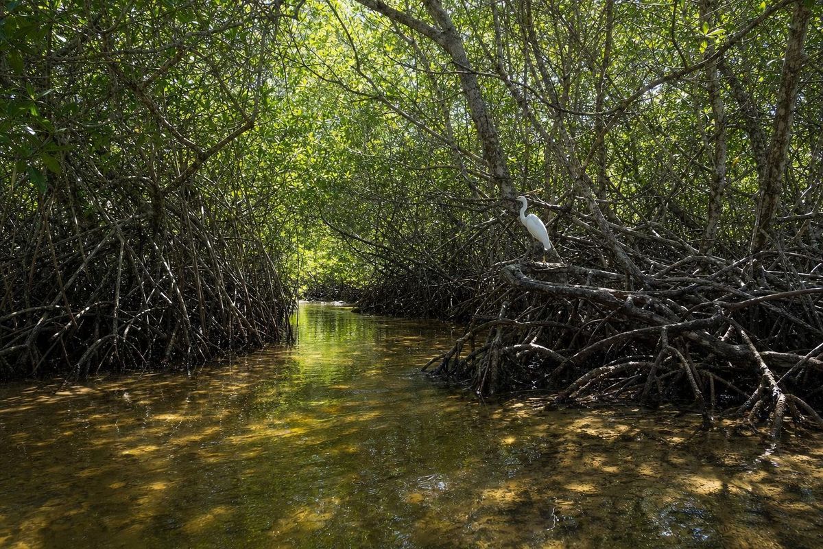
The Celestún biosphere reserve protects a shallow coastal estuary, the Ría Celestún, together with its mangroves, springs, dunes and the forest islands behind it, on the border of Yucatán and Campeche. It covers roughly 81,000 hectares and is best known for its flamingos, but the reason the birds are here is the water: fresh springs on one side, the Gulf of Mexico on the other, and a long lagoon where the two mix.
What makes the Celestún biosphere reserve work
The Yucatán peninsula has almost no surface rivers. Rain soaks straight through the limestone and moves underground towards the coast, and in a few places it comes back up. Along the west coast it surfaces in springs, locally called ojos de agua, in the floor and banks of the ría. Some geologists link the especially strong flow here to the ring of cenotes that traces the buried edge of the Chicxulub impact crater, which channels groundwater towards the coast at Celestún in the west and Dzilam in the east.
That fresh water meets seawater entering from the southern mouth of the estuary. The result is a gradient: brackish near the springs, saltier towards the sea, warm and very shallow almost everywhere. Algae, seagrass, small crustaceans and fish thrive in it, and everything that eats them follows.
A sandbar a few hundred meters wide separates the lagoon from the open Gulf. Celestún town sits on that bar.
Four kinds of mangrove
Mangroves line almost the whole ría. The reserve holds all four species found on Mexico's Gulf and Caribbean coasts, and they sort themselves by how much salt and flooding they tolerate:
- Red mangrove stands in the water on arching prop roots and forms the green walls along the channels.
- Black mangrove grows a little further back and pushes pencil-like breathing roots up through the mud.
- White mangrove prefers higher ground with less flooding.
- Buttonwood sits at the dry edge, where the mangrove grades into scrub and forest.
The roots shelter young fish and crabs, trap sediment, and soften storm surges for the town. Where seawater has flooded areas that were once fresher, or where storms have changed the water flow, stands of mangrove have died and bleached into the gray, skeletal stretch that boat crews call the petrified forest. It is not fossil wood, only dead trees that have not yet fallen.
Behind the mangroves are petenes, round islands of taller tropical forest that rise out of the marsh wherever a spring feeds them. The same landscape continues south into Campeche, where a neighboring reserve is named after them.
Flamingos and the other birds
The American flamingo is the famous resident. Large numbers winter and feed in the ría, usually peaking from about November to March, before many move north and east to the nesting grounds around Ría Lagartos. Their pink color comes from carotenoids in the brine shrimp and other small animals they filter from the mud, and young birds stay grayish until their diet has colored them.
The flamingos are only part of the list, which is often put at around 300 species. Look for roseate spoonbills sweeping their bills through the shallows, white ibis, tricolored and little blue herons, reddish egrets, cormorants, brown and American white pelicans in winter, magnificent frigatebirds over the coast, ospreys and several kingfishers. Migratory ducks and shorebirds swell the numbers in winter.
Away from the birds, the reserve holds crocodiles in the quieter channels, and sea turtles nest on the protected beaches in the warm months.
Visiting the reserve from Celestún
Almost all visits are by boat, leaving either from the dock beside the bridge on the road into town or from the beach in town. A typical loop runs to the flamingo flats, past the petrified forest and a roosting island, then into a tunnel of mangroves that ends at a spring with a boardwalk, where a swim is sometimes possible depending on current rules. Practical details on the town, the beach, the drive from Mérida and boat departures are on the Celestún guide.
Boat routes, prices and what is open within the reserve change, so treat any fixed figure with suspicion and check locally. Flocks also move with water levels and food, so two tours on the same day can see very different numbers.
| Habitat | Where you see it | Look for |
|---|---|---|
| Open shallows | Upper ría, away from the channels | Flamingos, spoonbills, pelicans |
| Mangrove channels | Narrow side channels and tunnels | Herons, kingfishers, crabs |
| Springs | Boardwalk stop on most loops | Clear water, small fish |
| Dead mangrove | The petrified forest | Cormorants, ospreys perching |
Seasons, light and weather
Winter is best for numbers of birds, but it is also the season of nortes, cold fronts that bring wind, cooler air and choppy water, and can stop boats for a day. Mornings are calmer and better for photography than afternoons, when the sea breeze picks up. The summer is hot and humid, mosquitoes are worse, and the hurricane season, roughly June to November, can bring heavy rain.
Visiting with care
The reserve is federal land managed by CONANP, Mexico's protected-areas commission, and boats are expected to keep their distance from flocks. If a boat gets so close that the birds lift off, they lose feeding time, and that matters during a cold spell. Ask to drift rather than chase.
- Use reef-safe sunscreen or none before swimming at the spring, and do not feed fish or birds.
- Stay on boardwalks where they exist; mangrove mud is soft and the roots are easily damaged.
- Pack out any rubbish, including small things like bottle caps that end up in the lagoon.
The same kind of coast, with flamingo nesting colonies and salt pans, continues on the north shore around El Cuyo and the old Maya port of Isla Cerritos. For a forest walk with a different set of birds, the private Reserva Toh near the Caribbean coast is another option. More water landscapes are listed under Lakes & Rivers.
About the reserve
When did Celestún become a biosphere reserve?
The area had earlier protection as a refuge and later as a special biosphere reserve; it was declared the Ría Celestún Biosphere Reserve in 2000 and is also listed as a Ramsar wetland of international importance.
Why are the flamingos in Celestún pink?
Their color comes from carotenoid pigments in the brine shrimp, small crustaceans and algae they eat. Young flamingos are grayish and turn pink over time.
Can you swim in the Celestún reserve?
Swimming is usually limited to the freshwater spring stop on the standard boat loop, and only when local rules allow. Swimming elsewhere in the lagoon is not part of normal visits.
Is the petrified forest really fossilized?
No. It is a stand of mangroves that died, probably after changes in salinity and water flow, and has bleached in the sun. The trunks are dead wood, not stone.
Which part of the reserve is in Campeche?
The reserve extends south from Celestún along the coast across the state border into northern Campeche, where much of it is marsh, mangrove and forest islands with no visitor access by road.
Nearby on the map
AI-generated image Towns & Villages · Yucatán
Celestún
AI-generated image Maya Ruins · Yucatán
Oxkintok
AI-generated image Haciendas · Yucatán
Hacienda Ochil
AI-generated image Towns & Villages · Yucatán
Mérida