
−20 m · Stone · Maya Ruins · Yucatán
Acanceh Ruins: the Pyramid of Masks and the Stucco Palace Frieze
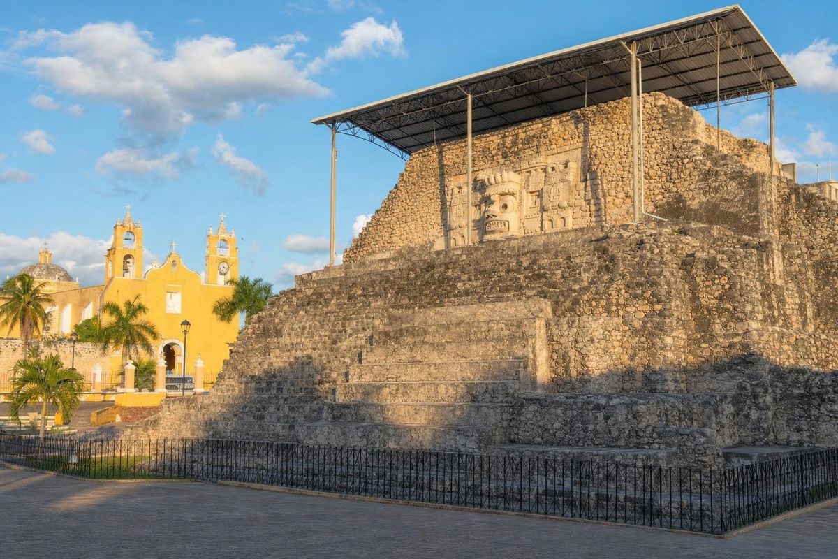
The Acanceh ruins sit inside a living town about 25 kilometers southeast of Mérida: a stepped pyramid with large stucco masks rises straight off the main plaza, and a few blocks away a raised acropolis holds one of the most unusual stucco friezes in the Maya world. Most of the ancient city lies under the streets and houses, so a visit is short, compact and easy to combine with Mayapán or the cenotes of Cuzamá.
A Maya city that never really emptied
Acanceh is usually translated from Yucatec Maya as "moan of the deer" or "groan of the deer." Pottery found here points to people living on the spot by the middle of the first millennium BC, which places the beginnings of the settlement in the Preclassic. The buildings that can be seen today are mostly Early Classic, roughly AD 250 to 600, a period from which the northern lowlands have relatively little visible architecture.
That early date is what makes the site interesting to archaeologists. The masks and the frieze show links to styles far from northern Yucatán. Several features have been compared with the Petén, around Tikal, and with Teotihuacan in central Mexico, whose influence spread through trade and diplomacy in the Early Classic. One building on the acropolis uses the sloping-and-vertical wall profile known as talud-tablero, the signature of Teotihuacan architecture.
Unlike many Maya cities, Acanceh was never fully abandoned. Spanish sources of the colonial period mention it, and after the conquest the newcomers took stone from the old platforms to raise their church and houses. This is why the ruins and the town are so tangled together today. The pyramid shares its plaza with the church, a few shops and a bakery, and garden walls along the acropolis are built from ancient blocks.
Survey work in the late twentieth century recorded well over a hundred structures across the area of the old city, almost all of them buried, flattened or built over. The two complexes open to visitors are a small fraction of what once stood here.
The Pyramid of the Masks on the plaza
The first thing anyone sees is the Pirámide de los Mascarones, a terraced pyramid on the town's central square. Its upper tier carries the reason for coming: large stucco faces set on panels along the stairway. Scholars think there were once eight; five survive, and they are now sheltered by a metal roof. An earlier thatched cover burned during a town celebration, and the fire damaged parts of the stucco.
The faces have squared, L-shaped eyes, ear ornaments and tied headbands. Most specialists read them as images of the sun god, K'inich Ajaw, or of rulers shown in the guise of that god, an identification common for Early Classic masks in the Maya area. The closest comparison in the region is the Temple of the Masks at Kohunlich in southern Quintana Roo, where similar faces sit on stepped panels beside a stairway. Some of the details, such as the shape of the eyes and the three-part headband, have been described as carrying older Olmec conventions forward into Maya art.
Karl Taube and others have argued that masks set into small panels like these can be read as shrines tied to dead and deified rulers, places where the ancestors were called up in fire ceremonies. It is one interpretation among several. A burial was found in the pyramid, which fits a funerary use but does not prove it.
A wooden stairway lets visitors climb to the level of the masks when the site custodian opens it. From the top there is a clear view over the town's flat rooftops and the bell towers of the church.
The Stucco Palace and its animal frieze
The second complex, the acropolis, is a large platform a few streets from the plaza. It is surrounded by houses, and access normally depends on the custodian unlocking a gate. On top stand the remains of several rooms and small temples, and one of them, the Palacio de los Estucos, holds the frieze that has kept researchers arguing for more than a century.
The frieze runs along a wall in horizontal bands. Its central band is divided into panels, each framing a figure: a rattlesnake, birds, a jaguar, a lizard, a figure with a reptilian head, a seated person with a speech scroll and other creatures, several drawn with human traits. The English artist Adela Breton copied it in 1908, soon after it was exposed, and her drawings remain an important record because parts of the stucco have weathered since.
Interpretations vary.
- Many scholars now link the figures to the wahy (also written way), spirit companions or co-essences that Classic Maya texts associate with rulers and ritual specialists, often shown as animals or animal-human hybrids.
- An early twentieth-century reading treated the panels as a kind of Maya zodiac, matching the animals with constellations along the sun's path. Few specialists accept that reading today, but it still turns up in guidebooks.
- Others stress the Teotihuacan connection, pointing to the framing and the style of some figures.
The figures face in the same direction and sit inside rectangular moldings, which suggests a procession or a set of beings moving between worlds rather than random decoration. Standing in front of the panels, the detail that stays with most visitors is how soft the modelling is: whiskers, feathers and fingers worked in plaster about 1,500 years ago.
Getting to Acanceh
Acanceh lies on the road that runs southeast from Mérida toward Tecoh and Mayapán, a drive of well under an hour in normal traffic. Colectivos (shared minivans) and second-class buses connect the town with Mérida; departure points and times change, so they are best confirmed in Mérida on the day. With a car, the town fits easily into a loop that also takes in Mayapán to the south and the Cuzamá and Homún cenotes to the east, covered on the cenote route through Yucatán.
Many travellers base themselves in Mérida and make Acanceh a half-day trip. Parking is on the streets around the plaza.
Practical notes for a visit
The site is managed by INAH, Mexico's national institute of anthropology and history, and the ticket office sits on the plaza next to the pyramid. Opening times and fees change, so check them locally or on the INAH website before going. The custodian usually accompanies visitors to the acropolis to unlock it, which means arriving well before closing time helps.
There is little shade on top of either complex, so a hat and water make sense in the hot months from April to June. The roof over the masks is low, and photographing them works best in the morning when light comes in from the side. The town itself has a colonial church, a market and a couple of old haciendas on its outskirts; the masks on the plaza remain the reason most people stop, and the frieze is the reason a few of them come back.
For more Maya sites in the area, the Maya ruins section lists the other cities around Mérida.
Acanceh: common questions
What does Acanceh mean?
The name is usually translated from Yucatec Maya as "moan" or "groan of the deer." Deer were common in the region, and the Maya often named places after features of the natural world.
How old are the Acanceh ruins?
Pottery shows occupation from the Preclassic, several centuries BC. The visible pyramid and the Stucco Palace date mostly from the Early Classic, roughly AD 250 to 600.
Can you climb the Pyramid of the Masks?
A wooden stairway allows visitors to reach the level of the masks when the custodian opens it. Rules can change, so follow the instructions given on site.
How long does a visit take?
Both complexes can be seen in about an hour to an hour and a half, including the walk between the plaza and the acropolis.
Is Acanceh worth combining with Mayapán?
Yes. Mayapán lies a short drive south on the same road, and the two sites show very different periods: Acanceh the Early Classic, Mayapán the Late Postclassic.
Nearby on the map
AI-generated image Trips · Yucatán
Cenotes of Yucatán
AI-generated image Maya Ruins · Yucatán
Mayapán
AI-generated image Towns & Villages · Yucatán
Mérida
AI-generated image Haciendas · Yucatán
Hacienda Ochil